
Payload Options

INOVA DRONE EAGLE EYE 640
3-AXIS STABILIZED DUAL EOIR PAYLOAD WITH LASER POINTER
SPECS:
3-
Axis brushless stabilization:
Sony EV7500 30X optical zoom 1080p; HD camera;
FLIR 640X512 with 0-8X zoom;
20 mW green laser pointer;
Gimbal stabilization controller with auto tune;
Multi mode vibration isolation;
120 degree yaw rotation;
Universal payload mounting plate/ adapter system;
Auto defog and low light night mode;
Digital EO and IR image stabilization;
H.264 Ethernet HD video streaming output with 128/256 bit encryption;
PPM input for RC of modes;
12 V system input power;
On board SD card storage;
Approximate dimensions: 155 mm H x 138 mm W x 160 mm L
REMOTE MODE FUNCTIONS:
0-30X zoom on Sony block camera;
0-4X zoom on FLIR VUE IR synchronized with Sony;
Color pallet (WH, BH, RAINBOW);
Flat field correction;
Temp spot mode with digital thermometer readout;
Switch between IR and EO;
Gimbal control over pitch and yaw motion;
Green laser on and off
Versions:
Tau 2 640;
Vue Pro 640;
Boson 640
(
Other non ITAR versions are available)

INOVA DRONE RAVEN EYE
3 AXIS STABALIZED DUAL 10X EOIR PAYLOAD.
SPECS:
3- Axis brushless stabilization;
Tamron 10X optical zoom 1080p HD camera;
FLIR IR thermal imager with 4x zoom;
Gimbal stabilization controller;
Multi mode vibration isolation;
60 degree yaw rotation;
Universal payload mounting plate/ adapter system;
low light night mode;
Digital EO and IR image stabilization;
H.264 ethernet HD video streaming output with
128/256 bit encryption;
PPM input for RC of modes;
12 V system input power;
On board SD card storage.
Versions:
Quark 640 Version;
Boson 640 Version;
Boson 320 Version; (
Other non ITAR versions are available)

10X 3 Axis HD Camera Payload System
Features HD 1080p 10x optical zoom camera; m
High precision driving algorithm, independent IMU to control PTZ posture, attitude control accuracy reaches 0.02 degrees, the integrated precision servo drive module;
Point angle is 420 degrees, support 3-6S wide voltage input:
Micro-SD card slot is overhead to avoid the rain influence;
HDMI1.4 HD output port;
Support SBUS decoding module upgrade port, using the Micro- USB link to connect the computer to upgrade parameters; The F2.0 uses 1/3 colour CMOS4 image sensor which supports approx.4 million effective pixels (2688 x 1520)


ROUTESCENE LIDARPOD
LIDAR
Complete Turnkey Mapping System
Visualization, quality assurance, and post processing software
Based on Velodyne HDL-32 sensor
700,000 points per second
Dual returns
Infra-red 905 nm wavelength
Uses: Surveying, Mapping

PHOENIX LIDAR AL3-32
LIDAR
Visualization and processing software
Based on Velodyne HDL-32 sensor
Uses: Surveying, Mapping
2 hour flight time / 300 acres

TRILLIUM HD40
VISUAL AND THERMAL
720p HD Digital Video
Electronic Stabilization and Scene Tracking
30X Zoom
Laser Pointer
Environmentally sealed
Uses: ISR
3 hour flight time

FLIR DUO PRO R
VISUAL AND THERMAL
4000 x 3000 visible sensor
640 x 512, 30Hz thermal imaging
Gremsy T1 Gimbal
Radiometrics/temperature measurement
Uses: Inspection, ISR
4 hr flight time

UKRSPEC USG-302
VISUAL AND THERMAL
Full HD 1080p video with 30x zoom
640 x 480, 9 GHz thermal imaging
Gyro-stabilized gimbal
Uses: ISR
2.5 hour flight time
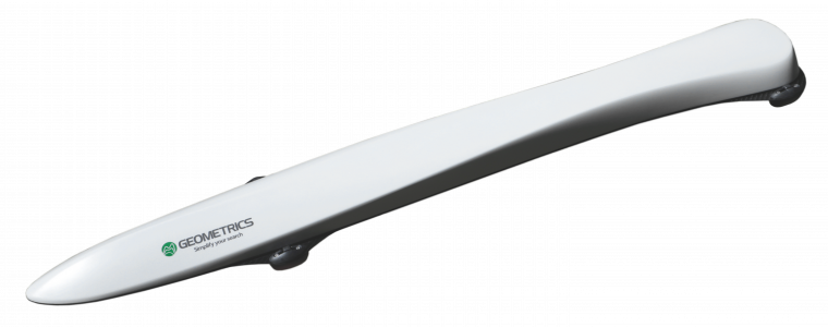
GEOMETRICS MAGARROW
MAGNETOMETRY
1nanotesla sensitivity
No data drop outs
Works in all orientations
Integrated IMU and GPS
Uses: Unexploded Ordinance / Wellhead Detection, Resource exploration
3-4 hour flight time

SONY A6500
VISUAL
APS-C Exmor sensor
24.2 MP
5-Axis in-body stabilization
11 frames per second continuous shooting
4K movie with 2.4X oversampling
Uses: ISR, Inspection, Mapping
3 hour flight time
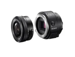
SONY UMC-R10C
VISUAL
APS-C size sensor
20 MP still image
Uses: Mapping
4 hour flight time

MICASENSE REDEDGE
MULTISPECTRAL
Five narrow bands 12 bit sensors
8cm/pixel at 400ft
Uses: Agriculture
4.5 hour flight time

SLANTRANGE 3P
MULTISPECTRAL
No network required.
Complete software suite for stitching + analyzing photos.
4 Spectral Channels. 4.8 cm / pixel at 400 ft AGL
4X area coverage, requiring minimal overlap
Uses: Agriculture
2000 acres in 4.5 hours at 26 mph @ 400 ft AGL